
At the time we lived in Raleigh in a neighborhood off of Hillsborough Street that is no longer there–long since taken over by N.C. State and is now underneath parking decks. This neighborhood was right behind the Red Barn restaurant between Dan Allen Drive, the train tracks and the Gregory-Poole Equipment Company.
The only road through the neighborhood was a single lane, “one-way street that was shaped like a giant horseshoe. We would line up our Schwinn Stingray-style bikes or skateboards, or little red Radio Flyer wagons at the top Friendly Drive, between the Red Barn and the Phillips 66, and just tear down the big hill and come out on South Dixie Trail–somewhere in the horseshoe near the witch’s house, Friendly Drive seamlessly became South Dixie Trail.
Here is a crude map.
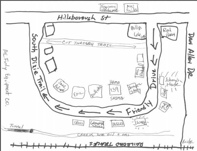
My parents, and my two younger sisters–Cheryl and Julie–lived at 139 South Dixie Trail until I was about 13 years old and the neighborhood was full of kids our age . There was Jimmy and Albert and David and Jane and Belinda and Eric and Frank and Cindy and Renee and many others but almost all the stories contain my best friend, Johnny .
All the kids knew each other and got together. Our neighborhood even had a witch, Mrs.Wade who lived in small, weathered old house. She lived next to Jimmy and Albert and her entire small yard was covered with kudzu and vines so that her small single-story house could not be seen easily.
This was in the 1960s. Long before Amber Alerts, mobile phones and parents arranging “play dates” for their kids. This was when you could go out on your bike in the morning and not come back until supper. We just rode our bikes all over the place–all the way down Hillsborough past the Bell Tower to the Capitol, over to Cameron Village and all over North Carolina State University.
My memories are filled with adventures straight out of the movies Sandlot and To Kill a Mockingbird.
Looking through the mistiness of memories and some old photos, I had a magical childhood.
